


تاريخ الفيزياء
علماء الفيزياء


الفيزياء الكلاسيكية
الميكانيك
الديناميكا الحرارية
الكهربائية والمغناطيسية
الكهربائية
المغناطيسية
الكهرومغناطيسية
علم البصريات
تاريخ علم البصريات
الضوء
مواضيع عامة في علم البصريات
الصوت
الفيزياء الحديثة
النظرية النسبية
النظرية النسبية الخاصة
النظرية النسبية العامة
مواضيع عامة في النظرية النسبية
ميكانيكا الكم
الفيزياء الذرية
الفيزياء الجزيئية
الفيزياء النووية
مواضيع عامة في الفيزياء النووية
النشاط الاشعاعي
فيزياء الحالة الصلبة
الموصلات
أشباه الموصلات
العوازل
مواضيع عامة في الفيزياء الصلبة
فيزياء الجوامد
الليزر
أنواع الليزر
بعض تطبيقات الليزر
مواضيع عامة في الليزر
علم الفلك
تاريخ وعلماء علم الفلك
الثقوب السوداء
المجموعة الشمسية
الشمس
كوكب عطارد
كوكب الزهرة
كوكب الأرض
كوكب المريخ
كوكب المشتري
كوكب زحل
كوكب أورانوس
كوكب نبتون
كوكب بلوتو
القمر
كواكب ومواضيع اخرى
مواضيع عامة في علم الفلك
النجوم
البلازما
الألكترونيات
خواص المادة
الطاقة البديلة
الطاقة الشمسية
مواضيع عامة في الطاقة البديلة
المد والجزر
فيزياء الجسيمات
الفيزياء والعلوم الأخرى
الفيزياء الكيميائية
الفيزياء الرياضية
الفيزياء الحيوية
الفيزياء والفلسفة
الفيزياء العامة
مواضيع عامة في الفيزياء
تجارب فيزيائية
مصطلحات وتعاريف فيزيائية
وحدات القياس الفيزيائية
طرائف الفيزياء
مواضيع اخرى

Equatorial Coordinate System
 المؤلف:
Diane Fisher Miller
المؤلف:
Diane Fisher Miller
 المصدر:
Basics of Radio Astronomy
المصدر:
Basics of Radio Astronomy
 الجزء والصفحة:
p71
الجزء والصفحة:
p71
 3-3-2016
 8069
8069


+
-
20
Equatorial Coordinate System
In the ecliptic coordinate system, the reference is the plane of the ecliptic that is, the plane formed by Earth’s orbit around the sun. The orbits of the other planets in the solar system, with the except of Pluto, lie within 7° of this plane. (Pluto’s orbit is inclined 17° to the ecliptic.) The coordinates of an object are given as celestial longitude, measured eastward along the ecliptic from the vernal equinox, and celestial latitude, measured north (+) or south (-) from the ecliptic. This system is handy for studying the solar system.
In the equatorial coordinate system, Earth’s equator is the plane of reference. Earth’s axis of rotation points to the north and south celestial poles. The celestial sphere is as large as the known universe, and Earth is at the center of this sphere. The celestial poles do not move as Earth rotates. For an observer standing at Earth’s equator, the celestial poles are on opposite horizons at exactly the north and south points, and the celestial equator passes overhead going exactly from the east to west horizon.
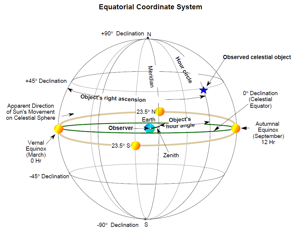
To describe an object’s location in the sky, we imagine a great circle through the celestial poles and the object and call this the object’s hour circle. Where the sun in its path crosses the celestial equator each year around March 21 is called the vernal equinox, and it is this line that is the reference for the east-west coordinate of the object. Because Earth’s axis is inclined 23.5° to the plane of its orbit around the sun, objects in the solar system (such as the planets and, from our perspective, the sun) move across the celestial sphere not along the equator, but rather in their own orbits, most of which are in nearly the same plane as Earth’s orbit. This imaginary path of the sun’s apparent motion, called the ecliptic, is a curving line that runs around the sphere ranging between 23.5° north and 23.5° south. The constellations of the zodiac all lie on the ecliptic. The object’s elevation above the celestial equator is called declination.
The coordinates of the object, then, are given by its declination and its right ascension or hour angle between the object’s hour circle and the vernal equinox. Declination is expressed in degrees (0° to +90° if north of the equator, 0° to -90° if south of the equator). Right ascension is expressed either in degrees (0° to 360° measured eastward from the vernal equinox) or, more commonly, in hours, minutes, and seconds of time (0 to 24 hours.(
Declination and right ascension are absolute coordinates regardless of the observer’s location on Earth or the time of observation. The only exception is due to the slight 26,000-year cyclic change in the equatorial coordinates because of the precession of Earth’s axis. Precession causes the stars to appear to shift west to east at the rate of .01 degree (360 degrees/26,000 years) with
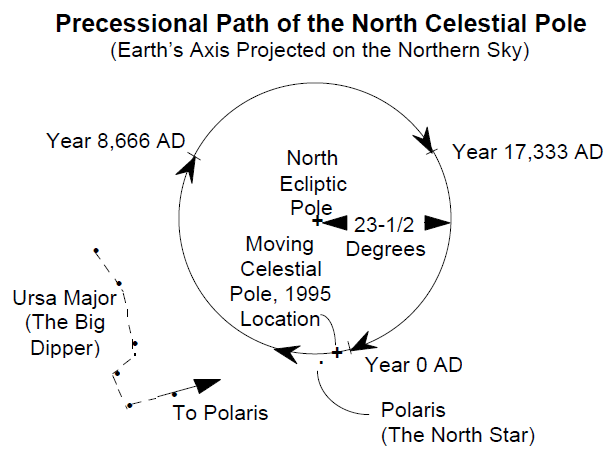
For this reason, sky almanacs identify the date and time of the instant used as the date of reference, or epoch, and provide equations for updating data based on the almanac to the current date. Epochs are named in 50-year increments. The 1950 epoch, for example, gives the coordinates precisely as they were on January 1, 1950.
Coordinates may also be given relative to the observer’s location and time of observation. The great circle that passes through the celestial poles and the zenith is called the meridian circle. The angle between the object’s hour circle and the meridian circle is the object’s hour angle. The hour angle increases with time, being negative before the object’s hour circle crosses the meridian and positive afterwards. Hour angle is measured either in degrees or hours, minutes, and seconds of sidereal time.
Radio telescopes are designed with mountings that are engineered to take best advantage of either the hour angle-declination (HA-DEC) coordinate system or the azimuth-elevation (AZ-EL) system (also called the altitude-elevation system, or ALT-EL). In an HA-DEC system, the HA axis is parallel to Earth’s axis of rotation. In this way, since Earth is turning toward the east, the telescope is mounted to turn toward the west (backwards) on an axis exactly parallel to Earth’s, thus cancelling out the east-west motion and simplifying the task of tracking objects in the sky. Thus, the mounting built for a telescope near the equator would appear different from one built for use in high latitudes. AZ-EL systems would appear the same no matter where on Earth they are being used.
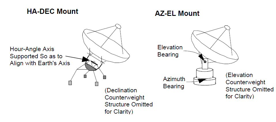
HA-DEC antenna mounting systems require an asymmetrical structural design unsuited to the support of very heavy structures. Their advantage is that motion is required mostly in only one axis to track an object as Earth rotates, although this advantage has largely been obviated by the use of digital computers that can drive both axes of AZ-EL systems properly while they track. The GAVRT uses an HA-DEC mount.
 الاكثر قراءة في مواضيع عامة في علم الفلك
 اخر الاخبار
اخبار العتبة العباسية المقدسة

الآخبار الصحية


 قسم الشؤون الفكرية يصدر كتاباً يوثق تاريخ السدانة في العتبة العباسية المقدسة
 "المهمة".. إصدار قصصي يوثّق القصص الفائزة في مسابقة فتوى الدفاع المقدسة للقصة القصيرة
 (نوافذ).. إصدار أدبي يوثق القصص الفائزة في مسابقة الإمام العسكري (عليه السلام)